A resistance mapping survey is underway which aims to provide preliminary data on the distribution of anticoagulant resistance in the Norway rat.
This survey is funded entirely by the pest control industry (BASF, Bayer, Bell, Killgerm, PelGar, Syngenta and also BPCA and NPTA) but is managed by an independent scientific committee to ensure that the results are seen to be both rigorous and independent.
|
Between 600 to 1,000 rat tail tips are required from seven areas across mainland Britain. The focus of the research is on a series of hot spots where it is known, or suspected, that the resistant rats occur.
Your help needed now
To establish the extent of the anticoagulant resistance on behalf of the pest control industry, the organisers require your help, now.
Shown below are the seven areas where the tips of rat’s tails are sought. The study is using spatial mapping by sampling along transects that cross resistance foci.
How you do it
Tail tips (3 – 5 cm) must not be from poisoned rats – they need to be collected from rats killed by trapping, shooting or dogs. Tails can be stored in a freezer until despatched in the supplied vial containing a preservative (one tail tip per vial). With each vial, certain data is required: the name of the collector, the date and place collected (a post code or GPS/Ordnance Survey map co-ordinate).
If you think you can help, email [email protected] or text 07852 975871 before collecting any tail tips. You will then be sent, free of any charge, an individually coded plastic vial contain 80% ethanol, along with instructions on how to collect your tails and where to send them once collected.
|
|
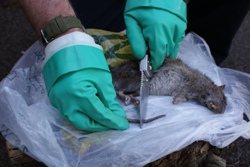 Cut 3-5 cm off the tip of the dead rat Cut 3-5 cm off the tip of the dead rat
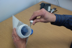
Each tail to be placed within a plastic vial and posted for testing
|
|
Tails can be collected along transects from the locations shown and areas in between:
Area 1 Avon – click here to view map
West to east: Bristol – Chipping Sodbury – Chippenham – Swindon – Wantage
North to south: Worcester – Tewksbury – Cheltenham – Cirencester – Devises – Salisbury
Area 2 Anglia – click here to view map
West to east: Kings Lynn – Dereham – Norwich – Great Yarmouth
North to south: Cromer – Diss – Ipswich
Area 3 Kent/South East England – click here to view map
West to east: Crawley – East Grinstead – Tunbridge Wells – Ashford – Dover
North to south: Gravesend – Chatham – Maidstone – Cranbrook – Hawkhurst – Hastings
Area 4 West Midlands/Wales – click here to view map
West to east: Dolgellau – Oswestry – Market Drayton – Stafford
North to south: Chester – Whitechurch – Telford – Bridgenorth – Kidderminster – Great Malvern
Area 5 Yorks/Lincs – click here to view map
West to east: Sheffield – Rotherham – Worksop – Retford – Horncastle – Skegness
North to south: Hull – Brigg – Market Rasen – Lincoln – Grantham
Area 6 Central England – click here to view map
West to east: Andover – Basingstoke – Farnborough – Woking
North to south: Oxford – Didcot – Newbury – Whitchurch – Winchester – Eastleigh
Area 7 South West Scotland – click here to view map
West to east: Stranraer – Newton Stewart – Castle Douglas – Dumfries – Gretna
|
